Small snowpack melts early
By SVI Staff
April 8, 2026
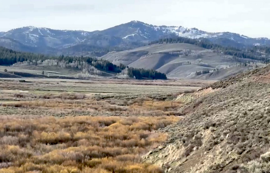
The Caribou Highlands west of Star Valley were first to melt out in this low snowpack year as pictured here at Stump Peak in early April. Water levels, traditionally running high in the streams around Star Valley, are abnormally low for the this time of year. SVI PHOTO/DAN DOCKSTADER
By DeMont B. Grandy,
Natural Resource Specialist
Lincoln Conservation District
It has definitely been an interesting water year since October 1, 2025, so far. Currently, many local snowpacks are melting out early except in the higher elevations. Overall snowpack levels in the local area are at historical low levels. This does not mean that overall precipitation levels since the start of the new water year are at record lows. This past water year’s local climatic temperatures were abnormally high resulting in rain rather than snow accumulation. The overall total precipitation levels as of April 1, for the Snake River Drainage basin is 107 percent of median, the Lower Green River Basin is 91 percent of median, and the Upper Bear River Basin is 97 percent of median. There probably will not be a lot of heavy river runoff levels this year but sustained water flows early in the season could be near normal levels if precipitation events become wetter. The month of March precipitation levels were drier than normal, which was not good. Overall precipitation accumulated levels through the local drainage basins are dropping fast now. It is hard to tell what is going to happen since this water year has been such a conundrum. A lot of future weather forecasts predict drier than normal weather conditions but this year so far has been erratic, making it difficult to determine any long-term trends.
Centering on local snowpacks as of April 1, this year, the Snake River Drainage Basin’s snowpacks’ Snow Water Equivalents (SWE) was 72 percent of median, lower than last year’s median of 107 percent. The Salt River Drainage Basin’s snowpacks’ SWE ranged from a high at the Cottonwood Creek Snotel Site at 62 percent of median, snow depth around 37 inches, to a low at the Grover Park Divide Manual Snow Course at 0 percent of median, melted out. The Greys River Drainage Basin’s snowpacks’ SWE ranged from a high at Blind Bull Sumit Snotel Site at 95 percent of median, snow depth around 53 inches, to a low at the Spring Creek Divide Snotel Site at 86 percent of median, snow depth around 58 inches. The high elevation Snotel Sites still have good snowpacks as expected. The water supply forecast for the Greys River near Alpine and the Salt River near Etna, as of March 1, appeared to be trending between 80 to 100 percent of median if future precipitation events were near normal.
The Upper Bear River Drainage Basin’s snowpacks’ SWE, as a whole, for April 1, this year, was 40 percent of median compared to last year’s snowpacks’ SWE at 98 percent of median. The snowpacks’ SWE in the Cokeville, WY, area ranged from a high at the Kelley Ranger Station Snotel Site at 55 percent of median, snow depth around 14 inches, to a low at the Big Park Manual Snow Course at 50 percent of median, snow depth around 21 inches. The head of the Upper Bear River Drainage Basin’s SWE ranged from a high at the Trial Lake Snotel Site at 61 percent of median to a low at the Lily Lake Snotel Site at 0 percent of median, melted out.
The Water Supply Forecast for Bear River above the Woodruff Narrows Reservoir as of March 1, this year’s trend was around 60 percent of median, the Smiths Fork River at Border trend was 98 percent of median if future precipitation events were near normal.
The Lower Green River Basin’s snowpacks’ SWE, as a whole, for April 1, this year was 28 percent of median compared to last year’s snowpacks’ at 100 percent of median., Snowpacks’ SWE in the Upper Hams Fork River Drainage Basin ranged from a high at the Indian Creek Snotel Site at 63 percent of median, snow depth 40 inches, to a low at the Hams Fork Snotel Site at 0 percent of median, melted out. The Henry’s Fork River Drainage Basin snowpacks SWE ranged from a high at the Steel Creek Park Snotel Site at 66 percent of median to a low at the Hewinta Snotel Site at 0 percent of median, melted out.
The Water Supply Forecast for the Hams Fork River below Viva Naughton Reservoir as of March 1, this year’s trend was around 80 percent of median if future precipitation events were near normal.
As of April 1, Viva Naughton Reservoir is around 82 percent of capacity.
It will be important that precipitation is received this coming month to stimulate spring vegetative growth on local rangelands and croplands. There is still hope for spring rains to offset the current drought trend. Let’s see what April brings.
Individuals wanting more snowpack/water forecast information may contact the Lincoln Conservation District (LCD) Field Office at (307) 279-3256 Ext. 3 or the Wyoming State Engineer’s Office in Cokeville at (307) 279-3441. A tabulation worksheet of daily statewide Snotel site measurements may be taken off the internet at www.wrds.uwyo.edu/wrds/nrcs/